 Live Music Archive
 Librivox Free Audio
 Metropolitan Museum
 Cleveland Museum of Art
 Internet Arcade
 Console Living Room
 Books to Borrow
 Open Library
 TV News
 Understanding 9/11
tv Red Eye FOX News September 3, 2010 3:00am-4:00am EDT
3:00 am

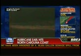
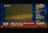
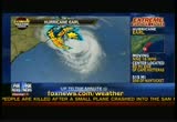
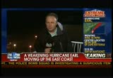
it start at 5:00 a.m. eastern. that's just a couple hours from now. >> have a good evening. this is a fox news alert. i. earl's winds have weakened, but hurricane warnings are in effect and people are urged not to take this storm lightly. north carolina's outer banks were the first to get hit. the national weather service says waves could reach 18 feet over the next few hours. >> we have live team coverage for you. we are in montoc, new york. our meteorologist in the extreme weather center and steve hariggan is in virginia beach, virginia, where they are awaiting earl's heavy rains and high winds. steve, what's it like so far?
3:01 am
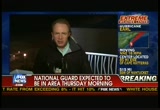
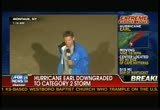
>> reporter: none of that rain hitting yet. the winds have gotten slightly stronger with gusts up to 30 or 40 miles per hour. they expect the eye of the storm to pass 100 miles offshore here in virginia beach. so they don't expect too much physical damage. 200 national guard troops have been moved to the coastline in case they are necessary and shelters have been set up for as many as 20,000 people. that doesn't look like it's going to happen so far. throughout the day, we saw people boarding up their houses with plywood or hard plastic. but a lot more cureiosity. even righted now, we have a number of people walking along the boardwalk or the beach. gusts of winds, but not a sense of impending peril here. some real concerns about the economic potential that this storm could bring, some major events scheduled for this weekend, a large concert and a large half marathon. so travelers expected here. they are going to have
3:02 am
difficulty traveling throughout this storm. >> steve, explain where you are perched and what is behind you? >> reporter: right here, along the beach on virginia beach. and behind me is the sand and is a large boardwalk. all along this area are a number of hotels. what we are really seeing is a sense of cureiosity more than fear. you have a lot of people out on their balconies, watching to see how big these waves get. the storm should kick in really in an hour or so, as far as the heavy strength here. but virginia officials saying, even though it is declared that the state has dodged the bullet as far as major expected damage from the storm. >> yeah, the high winds and the rain, they may escape. but what about the beach erosion there? that's always a major concern for any coastal town? >> reporter: certainly, a
3:03 am

concern. also for swimmers, a concern about the rip currents. last weekend, they have 140 saved in one day. that's a concern over this weekend. they had the red flags up today, really keeping people out of the water or going up to the water up to their waist. a lot of surfers out there as well. but i think the next 48 hours, they are going to try as much as possible to keep people out of the water to limit the danger from the rip currents. >> steve, you are a veteran of many hurricanes, as our viewers know. how do you rank this one? is this -- is there a sense that the folks of virginia beach have dodged a bullet? >> reporter: i think that's certainly the case. right now, it's mild enough conditions, we can see a lot of young people walking on the boardwalk. no sense of destruction. the trees are slightly bending, but no debris flying. it's just a strong breeze at this point.
3:04 am
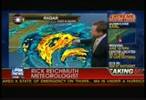
>> all right. we'll check back with you a bit later on. >> greg, even though some people are hanging out and watching what happens. this is moving north wampltd let's go to rick, with the very latest in the extreme weather center. rick, what is the storm doing right now? >> i was trying to look to see the buoy data. waves up to 12 feet off the outer banks here. this is the latest look at the storm on the radar picture. you can notice, center of the storm, generally, you have the small, compact eye. it is disintegrated, probably going through what would be an eye wall replacement cycle. and that weakens the winds just a little bit. so the strongest of the winds are across a wider area here. they are getting close here toward the outer banks. we will likely see winds up to hurricane force within the next couple of hours or so, but it will be quickly in a pretty small area that sees that. this is a water vapor image,
3:05 am

this shows a measure of the atmosphere at a much higher level from 10- to 20,000 feet in the atmosphere. we look at that to get a look at the steering currents for these storms. you will notice the dark air here. there has been high pressure here across the eastern seaboard keeping things extremely hot. record-breaking temperatures from new york city to maine. you have this, you see that white? this is moisture. this is dry air. dry air has been getting in, weakening the storm a little bit. but that's a player for us coming up. i will show you that. remember that. this is the storm and what's been happening, there has been high pressure that the storm has been moving around and it's continuing to pull off to the north-northwest. we have been saying it's going to make that right-hand turn. it's exactly where the high pressure builds. and sure enough tmade this right-hand turn, that will keep it from making a direct impact across the outer banks.
3:06 am

then we see a trough, a really strong system, the first fall air mass of the year is pulling in. this is the jet stream. these are the strongest winds we have in the atmosphere, they are going to quickly become the main steering force for the storm, pulling it off to the northeast. we will have the storm here tonight. by tomorrow night, up around cape cod and the islands. so a very quick-moving storm that will bring very big impacts for the next 24 hours. >> all right. thanks very much. well, heavy rains already hitting the outer banks of north carolina. the national hurricane center reporting winds of 105 miles per hour. those winds driving the rain sideways in places. and waves there? surf's up! 18 feet high. emergency management officials taking no chances. they are prepared to ride out the storm. north carolina state emergency center spokesperson joins us live on the phone from raleigh,
3:07 am
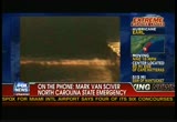
north carolina. mark, what is the situation there? >> reporter: well, right now, as you know, it's dark. and we are expecting the storm to be... just about at hatteras probably around 2:00 a.m. if it continues its tracking. we are seeing reports of rain and some minor flooding in coastal areas. but it's not been too bad. some high winds. so we are continuing to encourage people to stay at home, stay in the shelters. we have 17 shelters opened. approximately 5500 people in shelters as of right now. as far as storm, we are in the case of all hurricanes, we are just encouraging people to play it safe. >> well, mark, what's happened to this hurricane? >> reporter: well, thank goodness for all of us along the eastern coast tseems to be bearing a little bit further out
3:08 am
to sea. i don't know what will happen when it passes virginia and heads up further north. but as far as north carolina, it seems to be brushing our outer banks at this point. we have had some reports of some... some overflow along the outer banks. but no real estimates of damage at this point. we won't know until first light. >> we are looking at pictures streaming live. you do get a sense here, mark, that the waves are not that great in wrightsville beach. what's the situation coastally? >> reporter: wrightsville beach is further south, closer on the outer banks, where the outer banks jut out further to the atlantic than they would at wrightsville beach. so you are seeing more storm activity along that area. it's more of a question of how much storm surge we will see and how much wind damage. >> give us the timed period for
3:09 am

the storm surge, mark? >> reporter: well, probably started within the last hour or so and will continue hour or hour and-a-half at least. >> and then what? we will see where it goes by 8:00 in the morning, we think it will be up along the virginia/north carolina border. >> for coastal residents there? >> reporter: again, play it safe. they will see winds, storm surges and... and rain. >> but, mark, i mean, this strikes me as dramatically different than what many people have feared, correct? >> reporter: it certainly has not been a storm that has caused a lot of onshore damage like hurricane floyd or hurricane fran we had a little over 10 years ago. i think any storm is potentially
3:10 am

dangerous. i mean, it doesn't matter to somebody if they're killed by a category 5 storm or a tropical storm. you're still dead. >> yeah. absolutely. >> reporter: you do want to play it safe. our message is to play it safe. >> i don't want to minimize that. but when might we be out of the danger zone? >> reporter: i think that's something when the storm passes our border, when it passes north carolina's border, i think we will be out of the danger zone. have you to wait for the storm. >> right. >> reporter: it's like trying to herd geese. have you to herd them across the borderline and send them up the coast. >> we will check back with you. thanks so much. >> reporter: no problem. >> of course, there is the threat of flooding. any time have you high waves and low-lying areas, especially, they need to worry. >> and that always happens after the fact and they think, oh,
3:11 am

everything's okay. >> you know, we are tracking hurricane earl for you throughout the night and into the morning. >> the powerful storm hitting the eastern seaboard. look at the waves we have been following, churning up along the coast line, coming up next, we are going to hear from a member of the hatteras island rescue squad. obviously, in north carolina. that's where the eye of the storm is hitting right now.


3:14 am

>> welcome back, hurricane earl. we are covering it. hurricane earl's path is going to take it across the eastern end of new york's long island. beaches there already getting dangerous rip currents. fox news' rick levanthal is in montoc at the tip of the island.
3:15 am

what's it like? >> reporter: i heard you talking about beach erosion. that's a big concern for people here on -- on long island's east end in montoc. they have seen the waves churn up the past couple of days. we came to the sand to give you a different perspective. we are near high tide and a couple of waves swallowed me up and came up to this barrier fence here. there is a dune that runs along the beach. but there are breaks in that dune. and there are concerns that even if the hurricane steers east, the water will rise enough that they could have low-level flooding here. a tropical storm warning remains in effect. and they expect tomorrow, conditions will worsen to the point that we could have steady rains from new to 3:00 p.m. and winds tropical storm strength. >> what are officials doing to prepare? well. >> reporter: well, they have done quite a bit.
3:16 am
one of the most important thing, they closed the beaches to swimming. people were here on the sand -- or yesterday, i should say, to enjoy the sun. but they are not going in the water unless they are surfers. they have boards to keep them afloat. but they have shut down a couple of lines on the long island railroad in case trees come down. they have a lot of power trucks and 1600 extra workers ready to stand by if the power goes out. but most importantly, they are trying to keep the people out of the water. listen to this from earlier. >> the south side of the hamptons have 17 miles of beach and we have lifeguard stations on less than 2%. so we put a lot of personal responsibility to be cautious in storm environments. >> there is good news, of course, for the folks in montauk
3:17 am
and long island. but the last thing they wanted was for people to get scared and not come on vacation the last big weekend of the summer. the big concern is keeping people out of the water. so far as we can tell, people were not going in today and most likely will stay out. >> it's normally incredibly windy out in montauk. are you surprised about the conditions right now? >> reporter: yeah. we had gusts earlier. but the storm is quite a distance away. very calm right now. no rain yet either. we are expecting some rain overnight and certainly throughout the day tomorrow. but it's been beautiful here, quite honestly. i guess we are seeing the calm before the storm except the seas. the seas are violent. they have been 48 hours or so and aside from the surfers, it is not safe for people to go out there. >> live in montauk, rick, thanks so much. >> now the lateert on earl, forecasters say winds have
3:18 am

weakened to 15 miles per hour and by midday tomorrow could lower to a category 1. earlier residents and vacationers of cape hatteras island were told to brace for a direct hit. now forecasters say earl will stay far enough away. winds are expected to whip up to 75 miles per hour over the next few hours. we have bob healey, a member of the hatteras island rescue squad, live on the phone. hi, bob. thanks for joining us. what can you tell us right now? have people been heeding the warnings? and have you had to make any rescues? >> reporter: good morning. >> good morning. >> reporter: people have heeded the warning. and no, we haven't had to make any rescues. we have people carefully moving about in the field treporting back by radio what is being overwashed, in the usual places on highway 12, we are seeing overwash. we are standing by to do a first-line assessment and report
3:19 am

back to the county so they can coordinate with the state if there is any resources that need to be brought n. we are waiting for the eye to pass by and the winds to back through true north. and then we will be looking for some flooding. >> it's certainly good news that you did not have to rescue anyone. but you said you are on standby. i assume you are waiting -- i mean, do you expect to have to rescue anyone tomorrow? >> reporter: no. we hope all the reporters stay out of the surf. we hope not to make any rescues. tomorrow, we will be in an assessment mode. we are waiting for a combination of first light and the winds to come below 50 knots. >> what is your plan at first light? what are you going to do? >> reporter: we will see what the road looks like, where we can get to and from and see why
3:20 am

why -- see where the water level is. it will back up. >> what would you say the biggest threat is right now? or are you pretty much out of the woods at this point? >> reporter: well, it's wait and see. we are waiting for the winds to turn around and we will bring the sound side water back up. the north winds will push the water into buckston and hatteras villages and when it turns around all the way to the west, it will come to avon. >> we were hearing that a lot of people were evacuating on highway 12 and that it gets really backed up. you were talking about the fact that you are not quite out of the woods yet. did everyone make it out all right? did have you any calls of people having trouble getting out of town? >> reporter: no. we understand if there is a wreck or anything, we have to clear it quickly. we didn't have any of those. everybody got off okay. this is what they are talking about early evacuation, why when they say go, you should, because
3:21 am

right now, portions of the road may be overwashed. we have had people try to get through and it's too deep. >> all right. bob helle with the hatteras island rescue squad. thank you for joining us. >> reporter: have a good morning. >> you too. >> all right, about 100 miles off the coast line, looking at the national weather service, east of cape hatteras, waves could get as high as 18 feet. but in most areas of coastal new england, they're expecting anywhere from 2 to 4 feet. so the good news is it could have been a whole lot worse. >> 18 feet. those are really high waves. and the surfers are like, "great! great!" but you have to watch the rip currents. >> we are going to continue to track earl's path. >> coming up, we will take a look at where the eye of the storm is hitting right now and we will go to the weather center. stay with


3:25 am

>> we continue to follow dangerous hurricane earl's journey up the eastern coastline. and rich reichmuth is in the fox extreme weather center, following the very latest. >> you know, we just found our first hurricane-force wind at the top of the bonner bridge, to the north of cape hatteras. but 74-mile-per-hour wind gust, not sustained, but win gusts. that would have been that band of storms that moved on through. it tells you we are getting
3:26 am

stronger and stronger winds. if we see the last band that moves on through, probably that one, if it gets any closer, we will see stronger winds. here a the official path of the storm. it stays offshore here, across cape hatteras and it's farther to the east than it was earlier today, as we head into cape cod and the islands. take a look at what the impacts are. this orange area, that's hurricane wind gusts. that's sustained winds in the red. and the yellow is tropical storm-force winds. by 4:00 this morning, we have the hurricane-force sustained winds offshore, maybe gusts until 4:00 in the morning. tomorrow afternoon, we see maybe hugging that delaware coast line, as well as the jersey shore and areas of eastern long island. and then by around midnight tomorrow night, that's about the closest approach of any hurricane-force winds around nantucket and that will be pretty quick.
3:27 am

lasting just a couple of hours because the storm's going to be moving very quickly at this point. and by sunday morning, it's going to be looking very nice. >> let me be selfish. new york city and that area, what are we going to get? >> we are going to see winds 20-25 miles per hour gusting and a band or two of showers that move through. but in general, not a bad day. and i tell you what, it has been hot in the eastern seaboard. temperatures have been in the 90s up to maine all week long and the change will happen and it will feel like fall. temperatures will be in the 70s upon not to make light of the hurricane because it's a big deal. but the heat has been a big deal for a lot of people and we are going to get a very nice break. and so your husband's going to get surf up? >> there will be good waves for him out there. i wanted to ask rick one last question. i heard a drone flew into the storm to take measurements. is that something new or has that been around for a while? >> it's interesting. nasa has just put out their
3:28 am

first research mission since 2001, a u.s.-based mission. these are the drones that are flying into the storm to get a better idea really at the strength of hurricane forecasting or hurricane forecasts. we are very good at this point at saying exactly where a storm is going to go. we have very good ideas and models on the direction and the track of storm. we are not very good at predicting the strength of storms. sometimes with these storms, they tell intensify so quickly, it will be a category 4. these things happen very, very quickly. we are not that good at the forecasting of the strength. so they are doing this mission, the first one since 2001 to help us get more information and a better idea so we can kind of get better at that strength forecasting, which is certainly important for us. >> and that's safer than the hurricane huntedder planes. >> you love to get on the hurricane hunters and fly into a
3:29 am

hurricane -- sorry, geraldo, no room on the drone. >> no room on the drone. joining us, we have something riding out the storm. she's in north carolina in the banks in cedar point. krista, what can you tell us -- i know you decided to go ahead and stay. a lot of people decided to leave. we hear highway 12 was packed with people trying to get out of the area. but what made tudecide to stay? >> well, i live on the mainland two, miles from the island. so we would be able to get out if we have to. and also if you leave, sometimes the roads are flooded and you can't get back. >> what were people saying? what was the general idea? were people saying, let's get out of here? or were most people saying, let's ride it out. >> people thought you were crazy if you wanted to leave. i guess everyone's riding it out. >> did you get the necessary
3:30 am

supplies, just in case? did you see a lot of people out, stocking up? >> yes. they were out of water at the stores. and just essential supplies. so we got that and just hope that we are okay. it doesn't look so bad. right now. >> yeah, krista, i was going to ask, what does it look like right now? >> we have a little bit of horizontal rain. we had outer bands earlier. but i can't really tell since it's dark. but there is just high-force wind and rain right now. >> no flooding? >> not that i can see. >> and the streets? ummm, no, not that i can see. but it's also dark and there are no car, which is odd. >> eerie. what is it killdevil hills? >> this is the south outer banks. >> what's that? >> this is the south outer banks down here. >> right, right. but we are looking at a different picture. >> oh. >> and you are right. krista tdoes appear like
3:31 am

horizontal rain here. so it's pretty fierce, right? >> it is pretty fierce. but i have been through two others. and this is not as bad as the others seemed to be. >> you think the fact that a lot of people have been through storms like this made them complacment and think, oh, it's not going to do much? >> yes. i definitely think. i have a lot of friends that are still on the island and there was a mandatory evacuation. but they refused to leave their homes. so i hope they are safe there. >> krista, inevitably, we cover hurricane parties, you know, where people love to get together and they like to celebrate what's going on. any of that happening? >> there probably is. i have a 3-year-old. so i am not too aware of those parties. >> good for you. is your three-year-old sleeping right now? >> he sure is. >> sleeping right through t.
3:32 am
that's amazing. >> he is. >> were people pretty apprehensive about this thing? >> i think thisf they weren't originally from here, they are. the people who live here seem to think it's just another day. the people who are not originally from here were apprehensive. but i feel like we are reassured that it was okay. >> are you worried about any damage? first light, you might see some damage where you are? >> i am. we are more worried about the beach erosion because we had a lot of those -- i don't know how to say it -- renourishment projects. that cost millions of dollars and people are worried that it will be literally washed away. >> do you have jetties for the beach erosion or what? >> that, i am not exactly sure b. i have no idea about that. >> christ acedar point, north carolina. krista, good luck! keep it touch with us. when the sun comes up, let us
3:33 am
know. >> you hear about people who decide to stay put right where they are. >> okay. thank you. >> thanks. >> sometimes it works out, and sometimes it really doesn't. >> right. we have much more for ow hurricane earl's march up the east coast. we are going to learn how they prepared for earl in places like massachusetts. so stay with us. and if you are out in nantucket and you are tuning in, we have some info for you.


3:37 am
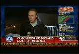
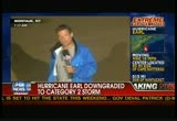
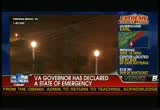
>> at the bottom of the hour, time for the top of the news on hurricane earl. >> that's right. the storm is continuing to march northward. earl's winds have weakened over the last several hours. warnings are still in effect with people urged not to take this storm lightly. >> the hurricane track has been bearing down on virginia beach, virginia, where steve hariggan is live with the latest. steve, what can you tell us right now? what's the storm doing right now where you are? >> reporter: steady wind right here where weer virginia beach, about 30-mile-per-hour gusts. no rain as you -- no rain as of yet. virginia beach has been preparing for the worst. the governor declared a state of emergency. they moved national guard troops to the coast and they prepared shelters to hold as many as 18,000 people. it looks like those steps were
3:38 am
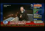
cautious but haven't been necessary. we haven't seen the heavy winds or the surge or any outage of power anywhere across the state. we are seeing people along the boardwalk, people walking really, cureiosity about the storm and the waves all along this resort area here and hotels, peopler their balconies, watching watching it come in. not a sense of dread or peril. but more cureiosity, people looking at the waves, looking at the storm without much sense of dread from its effects. >> tell us where you are, you say there are people hanging out on their balconies. why do you think there isn't that sense of dread? >> reporter: i think state fiduciaries over the last few hours have said that virginia did dodge the bullet here. and many of these people for tourists who have been following things closely. the one real concern was people swimming in the water. there were red flags and the only people in the water were
3:39 am

surf borders. everyone else was warned not to go in beyond their waists. they are expecting 50,000 people for an american music festeral and a huge half marathon. so have you people flying in. this is a very important tourist weekend for the city. so there are hopes that the storm won't prove too disruptive, as far as those events go. >> steve, i was going to ask but that. is the hotel full because of that? and what about additional people who wanted to, perhaps seek refuge there. were they able to go? >> reporter: there has been no evacuation here. the hotel has been very full so far. no reports on cancellations, how many people decided not to come. right now, both of those major events still plan to go ahead. they have built up sand berms to protect the stage for the music
3:40 am
show. but it looks like the beach is going to hold up. the waves 3 to 4 feet. and no sign of any structural damage along the beach. so it looks like the events are a go for those who braved it, for those who were able to travel here, both the race and the music events likely going to come off this weekend. >> that sounds like really good news for the local officials. have they said whether or not they are worried about people not coming out for this holiday weekend? >> reporter: certainly. that was their biggest concern. once they realized there would not be major structural damage and there was no real threat to property or life here, the next concern was tourism. this labor day weekend, very important for virginia beach. people have been planning for, hoping for for much of the summer. so a sense of relief so far that it looks like those events will not be disrupted by the storm. >> all right. that sounds like good news. thank you for that report. live in virginia beach. that's good news. it sounds like we are hearing a lot of good news. >> steve's going to put on his
3:41 am

dancing shoes and like pee wee herman. rick levanthal is in montauk, long island. the very, very tip of long island, have oftentime its takes the prunt of the storms. rick, what's the situation there? >> reporter: very calm right now, not much of a wind. we haven't had a drop of rainfall since we got here, much earlier friday. i'm sorry, thursday. the biggest effect that that we have seen so far is the waves. they're approaching us here on the beach. they are reaching the dunes here, we are approaching high tide, i should point out, so it's relatively normal to approach the dunes, but the seas are definitely swelling higher than normal. and they expect some potential for flooding here. but obviously, people are pretty grateful that this storm has turned towards the east and they are not going to take a direct hit because most of long island,
3:42 am

most of the coastal areas could be under water with a category 2 or a category 3. and that was a big concern. also the fact, there are 3 million people in sufunk and nassau county and no way to evacuate them all if the stompl were bearing down. people would be told to go to high ground and hunker down. so they don't have to worry about that. >> have people changed their plan, rick, because of earl? >> reporter: some have. we talked to one woman on the beach today who -- an older woman, who was there with her sister and her friends. she said she was a big chicken. she wasn't going to wait around. she was going to pack up and leave. the other people we talked to who were leaving had already planned on leaving tomorrow. and they were going to follow those plans. i can tell you that there are vacancies, appear to be vacancies in our hotel and the other hotels. we had no problem booking rooms. and the last week of summer, that's unusual in montauk, with how good the weather has been the past couple of days. >> it's an incredibly popular
3:43 am

place. now, look, rick, is there a group that is looking forward to the storm? >> reporter: well, we all know that the surfers love this. and we met a bunch of them out by the lighthouse here on the end of montauk, which is itself the end of long island. a great surfing spot. they say that the waves they have been seeing the last few day, saysay have been incredible. long wave, good curl, double headers in some cases. and they are expecting more of that over the next couple of days. here's more from one of the guys we sol talked to earlier today. >> usually when your muscles are cramping up, it's a good time. but i was talking to my friend and he said, have you to -- you have to push through that. so i don't know. maybe i'll try that sometime. >> reporter: what about the conditions? when are the conditions bad enough that you get out? >> i don't think there is one. what's your name? >> reporter: rick. >> rick, i don't think there is a condition where i wouldn't go out. have you to scare yourself every
3:44 am

day. that's how we do it. >> reporter: be careful, sal. all right? >> i'll try. >> reporter: greg, it is not just bravado, seeing them go out into the rough, rough surf. red flag, warnings. no one allowed in the water except the surfers because their boards are floatation devices. these guys know what they are doing, very, very choppy, churning waters and they were riding the waves. >> marianne's husband is a surfer. you ever get out in that stuff, rick? >> reporter: i tried it one time. i think i stood up on the board a second and-a-half. i can check it off the bucket list. >> that's all i could do, too. >> me too. my surfing days are over. >> normally, when we see you covering hurricane, you are just getting blown away and you are hanging onto a pole. >> reporter: yeah?
3:45 am

>> so this is a different rick leventhal we are seeing here? >> reporter: high and dry. except my feet which are getting swamped by waves every once in a while. you know, storms can be exciting. but they can be very dangerous. and as much as some people look forward to seeing storms rip ashore, nobody wants to see the downside, the bad effects. you know, there have been deaths associated with this storm as there are with most storms and that's why they put the warnings up. in this case, for us, there is not much action. we do expect tomorrow to get plenty wet. we will be here reporting in the heavy rains we are expecting throughout the day. but probably no more than tropical storm-force winds, and those numbers could drop. but we will have to ask rich reichmuth about that. >> a lot of people are happy to hear that. thank you very much, rick leventhal. we will check back with you, live in montauk.
3:46 am

thanks. >> reporter: great. >> mass is in a state of emergency and ted daniel took a look at the massachusetts coast guard preparing for the strongest storm in that state in 20 years. >> advisories are advised... >> reporter: they are reminded every hour on the hour of what lies ahead. >> gail-force and possibly tropical storm-force winds windm hurricane earl will affect the water. >> reporter: when the weather is at its worst, merrimack river and newbury port has to be at its best. this is one of only 20 coast guard surf stations in the country, meaning they specialize in bad weather and big waves. >> it can be scary. to try to do a rescue in those seas is more scary. so we train so our crew's very
3:47 am
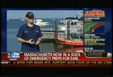
proficient. >> reporter: the main concern for this station, the area where the merrimack river meets the atlantic. yes, the north shore is expected to be spared the worst of the storm. but spared may be a relative term. >> to go out into it, it's a big adrenalin rush, but we are well trained to do it. >> reporter: with so much advance warning, the coast guard hopes boaters and swimmers to stay out of the water. regardless, they say they are ready and waiting for whatever earl may bring. >> should thing its get eighths bit crazy around here, we are fully capable. >> that was ted daniel from wfxt. >> want to take you to dare county, north carolina, famous near magshead. we have some videotape, just in to fox news. and here you can see some of the storm's effects. there is the beach. obviously, there are some
3:48 am
barricades up there... normally you would see on nags head, it is an open and exposed area on the outer banks. it is really a place that gets hit pretty hard, including cape hatteras. that gets hit hard. nags head always. and look at the wind. let's listen to this just for a second. wow. i mean -- that's pretty incredible. >> you hear it. it may not look like much. but you can tell by listening to it. >> and a lot of people are going to be walking out on the sand and they are going to see a whole lot less sand. >> we showed people kill devil hills. we were showing pictures from there. we were doing live reports from there. you can see the rain sideways like the person who decided to ride out the storm said it was coming in sideways and the wind
3:49 am
had really picked up. >> if you have ever been out in a hurricane covering it or just out in it, your face takes a beating. and you can -- listen to the pellets of water. this is live. and imagine -- >> standing out in it, which we have both done several times. as you are talking and you are trying to tell people what's going on. and it makes it more difficult. >> your face as well. incredible stuff. and so if you wonder: how in the world does that cause beach erosion? just listen to that. that kind of answers the question. >> that's what a lot of people are worried bthe expense and what that is going to do to their area. >> we will continue to track earl's path throughout the night and into the morning. >> up next, weil take a look -- a live look at where the eye of the storm is hitting and rich reichmuth will join us in


3:53 am

>> welcome back. fox news special coverage of hurricane earl, 85 miles east-southeast of cape hatteras right now, moving about 18 miles per hour. winds of 105 miles per hour, sustained. but gusts of about 120 miles per hour. meteorologist rich reichmuth in the fox weather center. give us the latest? [no audio]. >> all right. i apologize. we seem to have lost rick's audio. we are going to try to get back to him with the latest information. >> definitely. the eye of the storm is hitting the outer banks of north
3:54 am
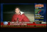
carolina. jonathan is in dare county, where he says there is concern about what is to come once the storm passes. jonathan? >> reporter: although hurricane earl was downgraded to a category 2 storm, it's still producing some heavy winds and as you can see behind me, some heavy surf. the long-term concern, of course, is beach erosion, the beaches of the outer banks attract numerous tourists from all corners of this country as well as many other countries. and the ongoing concern is whether it will wash away much of the sand here, even if the storm doesn't score a direct hit. we near dare county where there is a mandatory evacuation for all nonresidents. by and large, the tourists have heeded the warnings and left earlier in the day. but north carolina tourist promotion officials are hoping that many of them will come back over the labor day weekend. the storm systems is expected to move out very quickly. the brunt of the winds are expected to come during the wee
3:55 am
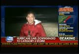
morning hours shortly after midnight. because the storm's been downgraded and taken a jog slightly to the east, forecasters don't believe that hurricane-force winds are going to strike the outer banks, but it's possible that they will experience tropical storm-force winds. what residents have been boarding up windows earlier in the day. most residents deciding to stay in their homes, but stocking up on supplies, just in case the storm turns out to be worse. in kill devil hills, fox news. >> thanks. you can barely hear him there for a second because of the wind. >> that's where nags head is. it always seems to somehow get the worst of it. 85 miles east-southeast of cape hatteras, 18 miles per hour is the movement. >> it's a category 2, 105-mile-per-hour winds and the winds can get up to 120 miles
3:56 am

per hour and sustained 15 miles per hour. >> it let's ghet the latest from rich reichmuth, standing by in the fox weather center. rick? >> hey t. helps if you turn the microphone on. i have that on. >> atta boy. >> we got the advisory. we get the advisories every 3 hours and complete every six hours. winds still 15 miles per hour. the strongest winds are on the right-hand side. none of those winds are on the west side of this storm, at this point. so that's good news. i don't think we will see the winds like that. but maybe hurricane-force winds like we have seen with the one reporting station will likely see more of that. interestingly enough, though, the pressure has gone up another 2 millibars, up to 955. that indicates that it continues to weaken, so that's certainly good news. take a look at the rain. orange is 3-plus inches of rain, over in this case, over the next six hours. we will see rain up and down the
3:57 am

eastern seaboard here and guy, you know that the lighter blues are 1/10 to half an inch and then head to new england and the southeastern new england and we will see a couple of inches. the reason the rain will be less is because the storm is moving quickly by the time it gets to that point. i will show that you in just a second. we expect to see this now, pull off to the north-northeast, not make anything landfall across the outer banks, which is great news for us. and by tomorrow, it stays off towards the east. this is by tomorrow night. so by tomorrow night, this area, southeastern massachusetts, starting to see probably the worst conditions and it will move very, very quickly. that's 8:00 p.m., by 8:00 a.m. saturday morning, we are talking about nova scotia. so it begins to move very, very quickly and into parts of the northeast and into canada. if we see any significant damaging storm surge from this storm, it is going to be to the right of it. that's across nova scotia at
3:58 am

this point, areas like nantucket and cape cod still potentially in the impact or direct impact, but i think it's a better chance that it will go to the east. strong winds tomorrow night. winds still up to hurricane force throughout that, maybe p.m. to 2:00 a.m. timeframe tomorrow night. >> so what? our lawns are going to get watered, rick? i mean, beyond that, what? >> >> games will be played. rain bands will come through very briefly, across the big and they will move out quickly. it is not a horrible day across the city. go to long island. 100 miles out, you will get quite a bit of rain and the winds maybe 40, 50 miles per hour. >> i live on long island. >> not your side of long island.
3:59 am

>> not my side. okay. that's all right. but all the people that got the heck out, maybe they can turn around and go back to wherever they were going on vacation. >> don't cancel your golf game. >> good news. >> rich reichmuth. thank you very much. >> we have a lot more coming up. we will talk about where the storm is headed. >> and we are close to top of the hour. so we want to reset for everybody who is just joining us, 2:00 a.m. east coast time. and out in the west coast, it's dramatically different. it's 11:00 at night. we are following hurricane earl right now. and it is moving about 18 miles per hour. it is about 85 miles east-southeast of cape hatteras and it's about 105 miles per hour, category 2. >> it was interesting, rick was saying the winds, or mainly on the outside, the really high winds. but people are going to feel it on the western side. >> officials are still warning to treat
322 Views
IN COLLECTIONS
Fox News Television Archive
  Television Archive News Search Service
Uploaded by TV Archive on
